On July 22.2009 ,Total solar eclipse may be seen in area shown in the picture below and other parts of India Partial eclipse will be seen .Click on picture to enlarge the picture.This solar eclipse will be one of those much waiting celestial phenomenon a total solar eclipse. It will be seen in India from 5.35 a.m. to 7.25 a.m. of July 22. and there will be a total eclipse for the duration of 6 minutes and 47 seconds.A total solar eclipse occurs when the moon moves between the sun and the earth, blocking out the sun from the areas in the moon’s shadow. Without the sun’s light, the sky darkens enough for stars to be seen and the corona makes a spectacular halo around the moon.Its suggested to utilize filters to watch this process.

General Maps of the Eclipse Path
The following maps show the overall regions of visibility of the partial eclipse as well as the path of the total eclipse through Asia and the Pacific Ocean. They use high resolution coastline data from the World Data Base II (WDB). Each map was chosen to isolate a specific region along the land portion of the eclipse path. Curves of maximum eclipse are included as well as the outline of the umbral shadow.
The maps are available as high resolution (300 dpi) PDF files.
| Figure Number | Title/Description | Map File |
| Figure 1 | Orthographic (Global) Map of 2009 Total Solar Eclipse | |
| Figure 2 | Map of 2009 Eclipse Path Through Asia | |
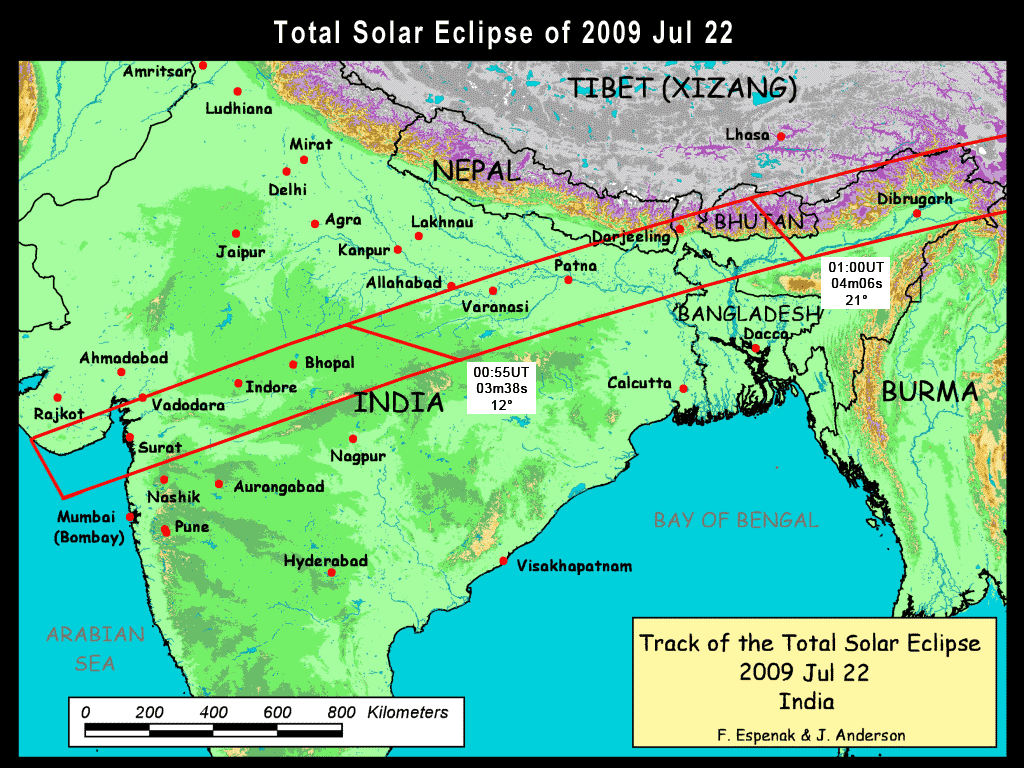
| Figure 3 | Map of 2009 Eclipse Path Through India and Bhutan | |
| Figure 4 | Map of 2009 Eclipse Path Through China | |
| Figure 5 | Map of 2009 Eclipse Path South of Japan |
From NASA Tech. Pub. "Total Solar Eclipse of 2009 July 22" (NASA/TP-2008-214169).
Detailed Maps of the Path of Totality
The following maps show path of the 2009 total eclipse in greater detail. They use high resolution coastline, city and highway data from the Digital Chart of the World (DCW). Each map was chosen to isolate a specific region along the land portion of the eclipse path. Curves of maximum eclipse are included as well as the outline of the umbral shadow. Within the umbral path, curves of constant duration have been plotted for totality.
The maps are available as high resolution (300 dpi) PDF files.
| Figure Number | Title/Description | Map File |
| Figure 6 | India - Mumbai | |
| Figure 7 | India - Bhopal | |
| Figure 8 | India (Patna) - Nepal | |
| Figure 9 | India - Bhutan | |
| Figure 10 | India - Burma - China | |
| Figure 11 | China - Chengdu | |
| Figure 12 | China - Chongquig | |
| Figure 13 | China - Wuhan | |
| Figure 14 | China - Shanghai | |
| Figure 15 | Japan - Ryukyu Islands | |
| Figure 16 | Japan - Iwo Jima | |
| Figure 17 | Marshall Islands | |
| Figure 18 | Kiribati | |
| Figure 19 | Phoenix Islands |
From NASA Tech. Pub. "Total Solar Eclipse of 2009 July 22" (NASA/TP-2008-214169).
tags: suraj grahan ,surya grahan,sun eclipse,eclipse on sun,solar eclipse 220709,solar eclipse 22/07/09,time of solar eclipse,effects of solar eclipse,nasa pictures,full solar eclipse cities and area,eclipse sun 22.07.09, 22/07/09,22-07-09,path of solar eclipse